Remembering the Mount Saint Helens 1980 eruption: 35 years later
- Dr. Janine Krippner
I have been a little obsessed with Mount St Helens for the majority of my life. The volcano, the precursory activity, the eruption, the science, and
the stories of the people whose lives were affected. The May 18, 1980
(and onwards) eruption is a major part of volcanology history and the 35th anniversary is a day to remember the events and the people whose lives ended or were changed that day. I have included a list of resources below that show different aspects of the eruption.
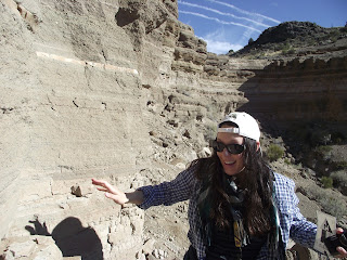
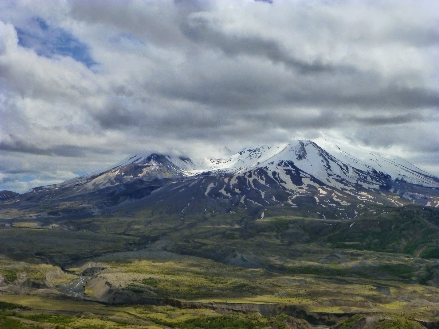
I finally visited the volcano in 2013. Driving up to the Johnston
Ridge Observatory I stopped to look at deposits along the way, impressed by the
protruding trees that were blown down and transported by pyroclastic density currents.
 |
| Trees removed during the 18 May 1980 eruption sticking out of the eruption deposits. |
Instead of jumping around excited like I
thought I would, when I came face to face with the volcano, with her collapse
scar, dome, and deposits I just stood there staring. Silent. I was looking at
the volcano ‘seeing’ the rising eruption column and the debris avalanche and
pyroclastic flows.
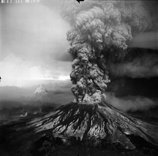
A magnitude 5.1 earthquake triggered a debris avalanche that transported 2.5 km3 of volcanic rock to the north and to the west. The removal of material, and therefore pressure, resulted in a lateral blast from the cryptodome that had been pushing the northern flank of the volcano horizontally to the north at 2 m (6.5 feet) per day. The directed blast moved at speeds of at least 480 km (300 mi) per hour, devastating an area an area of nearly 30 km2 and killing 57 people, most of whom were outside of the designated Red Zone. The large amount of melting snow and ice from the volcano produced lahars that buried homes downstream. Volcanic ash fell as far away as the Great Plains in central USA. (Summary information taken from USGS).
The eruption dramatically changed the landscape, and the lives of many who experienced that day. This post is dedicated to those who lost their lives, those who lost their loved ones, and those who were affected.
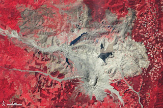
 | |||
| 3D image of Mount Saint Helens 35 years later. Image includes Landsat 8 OLI and ASTER data acquired 20 April, 2015, courtesy of the NASA Earth Observatory. |
 |
| GIF of the morphological changes to the summit of Mount Saint Helens after the May 18, 1980 eruption. Courtesy of the NASA Earth Observatory. |
The following resources give accounts of May 18 and the lives of those who were affected.
Video including interviews with USGS volcanologists that were monitoring the eruption.
---
---
Memories of those who remember the May 18 eruption (by HeraldNet, 2012).
---
A Scientific American article dedicated to David Johnston and James F. Fitzgerald Jr (Ph.D. candidate), the geologists killed in the eruption.
---
This interactive map shows that most of those who were killed were outside of the Red Zone, with a short description of each. This was a source of stress for the families at the time as some reports said they were where they should not have been.
---
Timeline of events from 1978 to July 22, 1980 by The Seattle Times.
---
USGS gives an account of the first minute of the eruption with the Rosenquist photographs.
 |
| Compilation of the Rosenquist photographs courtesy of USGS. |
Memories of those who remember the May 18 eruption (by HeraldNet, 2012).
---
A Scientific American article dedicated to David Johnston and James F. Fitzgerald Jr (Ph.D. candidate), the geologists killed in the eruption.
 |
| Dr David Johnston. Image credit: USGS. |
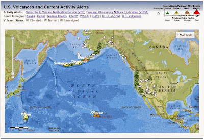
This interactive map shows that most of those who were killed were outside of the Red Zone, with a short description of each. This was a source of stress for the families at the time as some reports said they were where they should not have been.
 |
| The map of those who died in the eruption, the extent of the deposits, and the Red Zone. Clink on the link given above for the interactive map courtesy of The Columbian. |
---
A series of satellite images by the NASA Earth Observatory showing the recovery of the Mount Saint Helens area as seen from space (click on link for series of images):
 |
| NASA Earth Observatory image taken 24 September, 1980. |
---
The science behind the eruption: in recognition of the 35th anniversary of the eruption The Geological Society of America has made a collection of 10 key, highly cited Mount Saint Helens papers free here.
---
Collection of USGS photos of before, during, and after the eruption here:
 |
| The May 18, 1980 eruption. Image courtesy of USGS. |
---
A collection of photographs by Reid Blackburn, a photographer for The Columbian who was killed in the May 18 eruption here:
 |
| Contact sheet of photographs taken by Reid Blackburn that were developed years later. Courtesy of The Columbian. |
---
Learn about the monitoring efforts that keep a close eye on St Helens here.
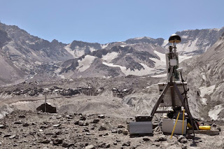 |
| Survey base station measuring deformation at Mount Saint Helens. Courtesy of USGS. |
---
Video footage taken by Dave Crockett who witnessed the eruption. The footage shows how the ash turned day to night under the eruption:
---
A few of the books about or including Mount Saint Helens (there are many more, these were handy sitting in my bookshelf).

---
Added 20th MayThis video includes the KATU 6 pm and 11 pm news covering the May 18th eruption on the day. The video has footage of the devastated area, interviews with geologists, helicopter pilots, discussions on those who are missing, and survivors as they arrive to safety.
 |
| Mount Saint Helens from the west, 2013. |